Geographic
Information System is software that is designed to capture geographic data. The
geographic data is used for various purposes such as creation of maps, urban planning,
and analysis of environment and planning of transportation. The fields such as environment
protection are using the GIS technology to evaluate the areas which are more
vulnerable to climate change and need environment protection initiatives. The
fields such as urban planning & transportation also use this technology. The
GIS technology has revolutionized the world and has provided various benefits
to the world. In future it is estimated that this technology will be used in
abundance and provide tone of opportunities to the world (Shellito, 2016).
Who in
these fields is
using GIS with
what kinds of
applications and why
are they using
GIS?
In the fields such
as environment protection, transportation and urban planning GIS is used in
abundance. In transport engineering the engineers use GIS for making
transportation plan. In urban planning and creating new localities the
developers use GIS to understand the area and how the locality should be
designed. The discussed fields use GIS technology to get information about the
geographic location. It is important to understand the region before starting any
project otherwise various faults can immerge in the future. Through analysis of
the geography one can provide a more suitable plan that benefits the society as
a whole (Shellito, 2016).
David Rumsey Historical Map Collection
From examining
some of the
historical maps in
both the Web
interface and on
Google Earth, how
do the areas
represented match up
with their modern-day
counterparts?
The
older maps does not provide that much detail as the new maps provide therefore
the older maps are different than the latest maps (Longley, Goodchild, Maguire, & Rhind, 2005).
Examine the “Chicago 1857” map. How
does this historic
map match up
with modern day
Chicago? You can
use Google Earth
to adjust the
transparency of the
map by using
the tools in
the Places Box
(select the slider
bar and move
it about half
way over )
- this will
enable you to
see current imagery
of Chicago beneath the geo referenced layer.
Are there any
areas that have
changed significantly between
then and now?
Source:
https://www.davidrumsey.com/luna/servlet/detail/RUMSEY~8~1~1570~190004
The
analysis of the Chicago map of 1857 indicates that there have been a lot of
changes our over the period of time. The today’s maps are more vivid and
colorful than the old maps. Through analysis of previous and today’s map it can
be seen that the positions of the road does not change much. The today’s map
shows various natural features of the area as well such as river lakes and
mountains. At that time the bus lines were also represented on the map but
today they are not included on the map. The old Chicago map was made prior to
the city was burned in the year 1871 (Map Of Chicago, 2018).
https://www.google.com/maps/place/Chicago,+IL,+USA/@41.8904756,-87.6574954,13z/data=!4m5!3m4!1s0x880e2c3cd0f4cbed:0xafe0a6ad09c0c000!8m2!3d41.8781136!4d-87.6297982
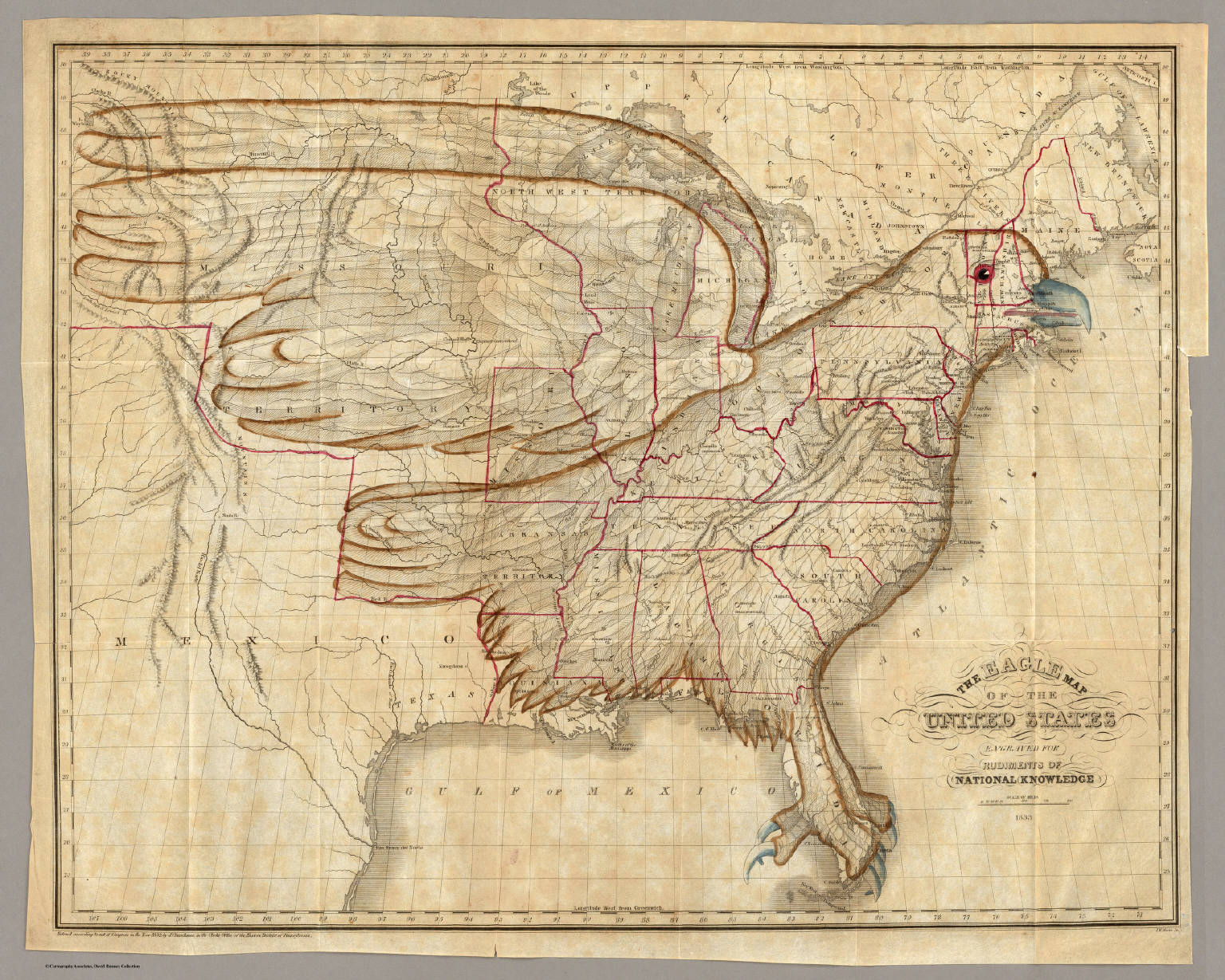
Examine the
"United States 1833"
map (the 'Eagle'
map with its
icon located in
Ohio), and make
the layer semi-transparent. How
does this map of the
United States match
up with current
boundaries and coastlines?
Source:
https://media.davidrumsey.com/rumsey/Size4/D0005/00054111.jpg
The
eagle map of United States has resemblance with today’s map of United States of
America. In the old map eastern coast line has a lot of similarities with the
current coast line however in the eagle map there were fewer cities were
mentioned as compared to today’s map. The today’s map shows more detailed coast
line and boundaries along with the more cities (Map Of Chicago, 2018).
Examining Google Street
View
How would
the imagery from
Street View be
helpful if you
were traveling to
Rock Hall as
a destination (and
had never been
there before)? There
are no parking areas
available immediately adjacent
to the Rock
Hall - how
could Google Street
View be more
helpful to you
than a road
map or an overhead view
in finding somewhere
to park?
The
Google street view provides 3D image of the street. The street views provides
actual image of the specific region and one can understand the area more
efficiently than the landsat imagery. For example if any wants to reach to the Rock
Hall as destination the street view imagery can help the drivers to reach the
location easily because all the major roads that leads toward the Rock Hall
provides Street view (Shellito, 2016).
Examine some
local areas near
you using Street
View. Which roads
are available with
Street View imagery
and which are
not (for instance,
is Street View
imagery of residential
areas available or
is it available
only on main
roads)?
All
the major roads usually have street imagery however the streets which are
smaller and away from the city centers does not provide street view. The
residential areas does provide street imagery however as discussed earlier the
miner roads does not provide street imagery (Shellito, 2016).
Live Landsat Imagery
What kinds
of features in the San
Diego region can
you easily identify
even with the Landsat
30m resolution?
In
the city of San Diego California USA the Land sat 30 m resolution provides
brief futures regarding the area. The
above pictures shows a locality located in San Diego and it can be seen that
the buildings, roads and other features are clearly visible (Longley, Goodchild, Maguire, & Rhind, 2005).
In
the most recent
available Land sat imagery,
is the Suffolk
Campus clear or
clouded in? What
types of local
features can you
identify with 30m
imagery?
The
above figure shows the Suffolk Campus and it can be seen that the Suffolk
campus is clearly visible and not clouded. The roads, buildings and natural
features are clearly visible in 30m imagery (Shellito, 2016).
References
Longley, P. A., Goodchild, M. F., Maguire, D. J.,
& Rhind, D. W. (2005). Geographic Information Systems and Science.
John Wiley & Sons.
Map Of Chicago.
(2018). Retrieved from https://www.davidrumsey.com/luna/servlet/detail/RUMSEY~8~1~1570~190004
Shellito, B. A. (2016). Introduction to Geospatial
Technologies. W. H. Freeman.


